
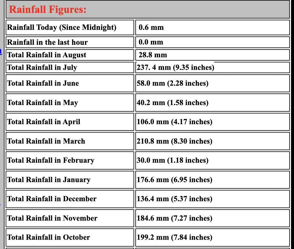
The news that July 2023 was the hottest month on record around the world has been met with some head-scratching by Buxtonians. According to local weather hero Michael Hilton who runs the legendary website buxtonweather.co.uk, the town’s endured 237mm (9.35 inches) of rain this July (double the average for July!), beating all of his own 20 year records and those of the Buxton Climatological Station on The Slopes, an official Met Office Weather Station, which goes back 160 years, into the 1860s.
Is the weather pattern that has plunged most of Europe into a state of “global boiling” is the same one that has left Buxton in the opposite extreme of “global drenching”?

Hours of sunshine and daily temperatures in July 2023 have been far below average too, with 123 hours of sun – some July months can see 240+ hours of sun.
Check out the monthly comparisons (image from Buxton Weather):
Donning jumpers and waterproofs for virtually the whole month, residents and visitors to Buxton will perhaps not be surprised by the news. Following a very warm and dry June, the rain began to fall at the start of July and many had the horrible feeling that summer had been and gone. Aside from the occasional dry hour, the only variation in weather has been in the type of rain; ranging from cold drizzle to thundery downpours. They say the Inuit have 50 different words for snow so perhaps the people of Buxton should extend their meteorological lexicon.
Why has Buxton weather been so bad and what is the jet stream?
Partly the culprit is a southern shift in the jet stream. The jet stream is a core of strong winds around 5-7 miles high up above the earths surface, blowing from west to east. Influencing wind patterns, air pressure and weather.
Sometimes, like in a fast-moving river, the jet stream’s movement is very straight and smooth. However, its movement can buckle and loop, like a river’s meander. This will slow things up, making areas of low pressure move less predictably.
In a typical British summer, when temperatures are warmer and drier, the jet stream sits to the north of the UK. It pulls up warmer air across the country. In winter it sits further south bringing wet and windier weather to the UK. Currently the jet stream is positioned to the south, bringing us the on-going poor weather, ‘locked in a rigid pattern’. This is also responsible for allowing high pressure to dominate in Europe, causing the extreme heat which has been commonplace recently.
Will it get any better?!
The question remains: Will it get any better? After all, summer isn’t over and there may be chance for a barbeque yet. For the foreseeable future, it looks like the forecast is for more perpetual precipitation. The best we can hope for is more agreeable conditions in the second half of August and September. According to Buxton Weather Watch – around the 10th and 11th August look promising for some more summery weather and possible temperatures of mid to the high twenties.
A decent weekend for local festival Eat in the Park would be particularly welcome! But perhaps don’t plan on putting away the umbrellas just yet. And what of Buxton in the future? With the extreme weather patterns becoming more normal, it could be that Buxton has to market its abundance of water somehow. Perhaps we could bottle the stuff and sell it to the rest of the world? Oh, hang on … Or maybe we could get some buildings with a massive pavilion or dome to keep dry? Oh, wait…
With thanks to Buxton Weather and Buxton Weather Watch for information included in this article. 😎


